USA
Introduction/Background
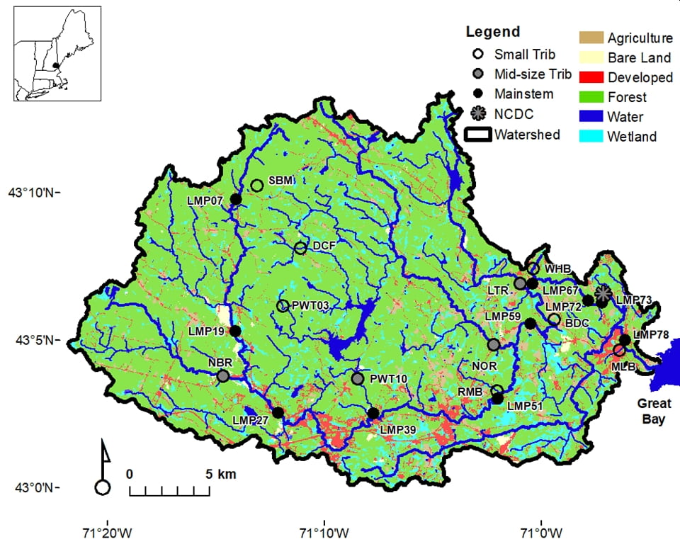
The Lamprey River Hydrological Observatory (LRHO) was established in 1999 to address the effects of suburbanization on hydrology, biogeochemistry and water quality. The LRHO is located in southeastern New Hampshire (USA) and comprises a basin area of 554 km2 that drains into the Great Bay Estuary (Figure 1). Segments of the Lamprey River are designated as Wild and Scenic (37.8 km of 80.8 km total) under the National Wild and Scenic Rivers Act (Public Law 90-542) by the U.S. Congress. Work in the LRHO is motivated by four overarching questions focused on interactions among suburbanization, climate and watershed-scale processes:
- How do suburbanization and associated changes in land cover drive long-term trends in surface water chemistry?
- How do watershed attributes influence surface and groundwater chemistry?
- How does suburbanization affect the long-term nitrogen (N) balance?
- What is the effect of changing seasonality and climate variability on watershed biogeochemical processes in a suburban landscape?
The Lamprey River Watershed
The LRHO includes nine headwater and mid-sized tributaries (first to fifth order) and the sixth order main-stem Lamprey River for a total of 21 nested sampling stations (Table 1). Although the watershed remains heavily forested (73%), it is characterized as suburban and a mixed land-use environment incorporating agriculture (5%), development (7%) and wetlands (10%; NOAA Coastal Change Analysis Program, 2016). Human population has been increasing by 0.45 people km-2 year-1 since 1990 (60 people km−2 in 2020) with housing density at 25 housing units km-2 (Coble et al., 2018). A vast majority of the watershed’s population utilizes on-site waste disposal (i.e., septic systems; Trowbridge et al., 2014). Impervious surfaces have been increasing 0.2% per year and now cover 5.8% of the watershed (NH Granit 2010). As a result of these changes, both salinization and nitrogen (N) loading have increased (Daley, 2002; Daley et al., 2009) with the receiving estuary classified as N impaired (Burack et al., 2009) in violation of the Clean Water Act.
This region of the northeastern United States is also experiencing changing seasonality due to global climate change resulting from the combustion of fossil fuels and changes to land use. Across New England, including New Hampshire, the rate of winter warming is outpacing the rates of warming for spring, summer, and fall (Burakowski et al., 2008). The ratio of snow to total precipitation has also decreased since 1975 with winter/spring high flows shifting to earlier in the year (Hodgkins et al., 2003; Huntington et al., 2004). The vernal window—the transition from winter to spring and the beginning of the growing season—is also moving earlier in the year with multiple hydrological and ecosystem consequences (Contosta et al., 2017) further evidenced by earlier dates for lilac blooms in the region (Wolfe et al., 2005).


